| Médias | Titre | Cote | Date | Lieu | Type de document | |
|---|---|---|---|---|---|---|
|
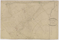
Résultat n°1
|
1 media |
Cote 6NUM10/143/003 (Cote)
|
Date 1827
|
Lieu
Pièce du Gué de Faux (Manthelan, Indre-et-Loire, France), Grand Champ (Manthelan, Indre-et-Loire, France), les Communs de Grand Champ (Manthelan, Indre-et-Loire, France), Pièce des Tailles (Manthelan, Indre-et-Loire, France), les Grandes Vallées (Manthelan, Indre-et-Loire, France), les Aunayes (Manthelan, Indre-et-Loire, France), la Billardrie (Manthelan, Indre-et-Loire, France), Pineau (Manthelan, Indre-et-Loire, France), la Bérangeraye (Manthelan, Indre-et-Loire, France), la Mignonnerie (Manthelan, Indre-et-Loire, France), Aubigny (Manthelan, Indre-et-Loire, France), Recelin (Manthelan, Indre-et-Loire, France), les Coteaux (Manthelan, Indre-et-Loire, France), Fripe, étang de la (Manthelan, Indre-et-Loire, France), Moulin du Pré (Manthelan, Indre-et-Loire, France), Fontenay (Manthelan, Indre-et-Loire, France), Fontaine de Fontenay (Manthelan, Indre-et-Loire, France), le Vigneau (Manthelan, Indre-et-Loire, France), Tailles de Villeret (Manthelan, Indre-et-Loire, France), Carroi Saint-Bauld (Manthelan, Indre-et-Loire, France), Prés de la Fuye (Manthelan, Indre-et-Loire, France)
|
Type de document
plan cadastral
|
|
|
||||||
|
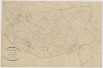
Résultat n°2
|
1 media |
Cote 6NUM10/143/005 (Cote)
|
Date 1827
|
Lieu
Monfoué (Manthelan, Indre-et-Loire, France), les Petites Varennes (Manthelan, Indre-et-Loire, France), le Chauché (Manthelan, Indre-et-Loire, France), Gué Mausay (Manthelan, Indre-et-Loire, France), la Grande Pièce (Manthelan, Indre-et-Loire, France), Carroi Saint-Bauld (Manthelan, Indre-et-Loire, France), le Pré Gallet (Manthelan, Indre-et-Loire, France), le Limousin (Manthelan, Indre-et-Loire, France), Pièce des Champs Ganeaux (Manthelan, Indre-et-Loire, France), Morignan (Manthelan, Indre-et-Loire, France), la Cotterie (Manthelan, Indre-et-Loire, France), le Pied de Biche (Manthelan, Indre-et-Loire, France), la Davière (Manthelan, Indre-et-Loire, France), la Chaude des Chênes (Manthelan, Indre-et-Loire, France), le Meneau (Manthelan, Indre-et-Loire, France), Vallée du Fourneau (Manthelan, Indre-et-Loire, France), le Champ Gâneau (Manthelan, Indre-et-Loire, France), le Pied Tord (Manthelan, Indre-et-Loire, France), la Place (Manthelan, Indre-et-Loire, France), Razine (Manthelan, Indre-et-Loire, France)
|
Type de document
plan cadastral
|
|
|
||||||
Ce site utilise des cookies techniques nécessaires à son bon fonctionnement. Ils ne contiennent aucune donnée personnelle et sont exemptés de consentements (Article 82 de la loi Informatique et Libertés).
Vous pouvez consulter les conditions générales d’utilisation sur le lien ci-dessous.